*Featured Photo by and Co-Written with Jaynie Ellis.
Located in the Town of Horicon, the Hamlet of Brant Lake has become a dream destination for outdoor recreation enthusiasts. And why wouldn’t it be? Not only does Brant Lake itself offer opportunities for boating and other water sports, but the various trails and terrains nearby create fantastic spots for mountain biking, cycling, and hiking.
So, naturally, it only makes sense that the Lake George Area’s newest hiking challenge take place around the peaks of Brant Lake. Think you’re up for the Brant Lake Challenge? Get ready to conquer some Southern Adirondack hikes with spectacular views.
Four Summits. One Goal.
The appropriately named Brant Lake Challenge consists of four different hikes, all of which are located near the hamlet of Brant Lake. While these trails may vary in length and difficulty, most of them are family-friendly, and all of them feature majestic views of the surrounding Adirondack Mountains, as well as nearby water bodies.
The Brant Lake Challenge Hikes include:
- Bartonville Mountain Hiking Trail - An easy 1.5-mile round-trip, out-and-back hike with stunning views of Brant Lake below, and a fantastic vista point perfect for picnics.
- Fox Hill Trail – A 1.6-mile round-trip, out-and-back climb with overlooks and views of Moxham Mountain, Mill Pond, and even Gore Mountain.
- Pharaoh Mountain Trail – Located within the Pharaoh Lake Wilderness, this 12.5-mile roundtrip hike is fairly flat for several miles, but has a steep ascent to the summit, with several campsites and lean-tos along the way.
- Swede Mountain Trail - A short 1.8-mile round-trip, with a historic 47-foot-high fire tower, offering panoramic views of nearby mountains such as Gore and Crane, as well as Brant Lake.
Feel free to complete these treks in any order, and at your own pace. Once you have successfully climbed all four, you can fill out a completion form on the Brant Lake Challenge website to have a certificate emailed to you, as well as be displayed on the website’s “Challenge Finishers” section.
*Make sure to keep track of the dates of your hikes for the Completion Form. Already completed them all? Fill out the Brant Lake Challenge Finisher Form today!
Those who have completed the Brant Lake Challenge can also receive a special patch by visiting The Hub, located on Market Street in Brant Lake. These patches are an excellent way to showcase your accomplishment, as well as your pride as an Adirondack hiker.
Gear Up & Get Going
Before setting out on any of these trails, please make sure you’re prepared and mindful of local rules and regulations. Even on a short trek, being ready for any situation is important and highly beneficial.
Below are helpful tips and suggestions to ready yourself for any hike.
What to Pack
- In certain sections, the path may be steep or rocky. Proper footwear, like hiking boots or sneakers, is required.
- Any forest trail can be buggy—especially in the summertime. To prevent swarms of mosquitos, horseflies, ticks, and other insects, don’t forget to pack bug spray. Longer sleeves and pants can also help, but dress in moisture-wicking fabrics so you don’t overheat!
- Make sure to pack plenty of drinking water, especially if hiking on a hot summer day! Snacks are also a terrific idea to enjoy at any overlook or summit.
- In case of rain, wearing a poncho or waterproof jacket will shield you from getting damp. Additional warm layers underneath will also help.
Hiking Rules and Tips
- If on a narrow trail, uphill hikers have the right of way.
- Please stay on the marked trails at all times.
- Follow the “Carry In, Carry Out” policy and take any garbage or belongings out with you.
- Do not disturb any of the wildlife or disrupt the natural environment in any way.
- Keep others notified where you’re going/headed in case of emergency.
- Monitor changing weather conditions and judge accordingly.
For even more hiking advice, check out the NYS DEC’s Hike Smart NY page.
Meet the Trails
Bartonville Mountain Hiking Trail
Distance: 1.5 miles roundtrip, out-and-back
Difficulty: Easy - Moderate
Location/Parking: The Hub – 27 Market St., Brant Lake
Trail Map: Bartonville Mountain Trail Map
You can begin your hike up Bartonville Mountain by parking in the gravel lot located at The Hub. In fact, you’ll find the trailhead just behind it.
From the trailhead, take the Jack & Jill Trail, which can be identified via the red trail markers. This path is separate from the mountain bike trails, making it exclusive and safe for hikers. Though the attached Brant Lake Bike Park is an outstanding trail system for mountain bikers, with over five miles—covering over 200 acres—of singletrack riding. If you have the time to do both, it’s certainly worth it!
Within the first half-mile of the Jack & Jill Trail, you’ll reach two overlooks, those being of The Hub and Mill Pond, between breaks in the trees. There are also several bald rock faces along the trail, with large boulders for sitting and taking breaks if needed.
Once you reach the wooded summit, with the open vista just ahead, you’ll be rewarded with a gorgeous view of Brant Lake from an elevation of 1388 feet. Take the time to admire the views, have a bite, and relax before making the trip back down.
Before or after your hike, you can grab some food at The Hub, like their delicious specialty items, including sandwiches, salads, and even pizzas. You can even prepare a picnic for the vista point near the summit.
Note: Though most trail maps will say this hike is “easy,” certain stretches in elevation may be of “moderate” difficulty for those who are not experienced hikers.
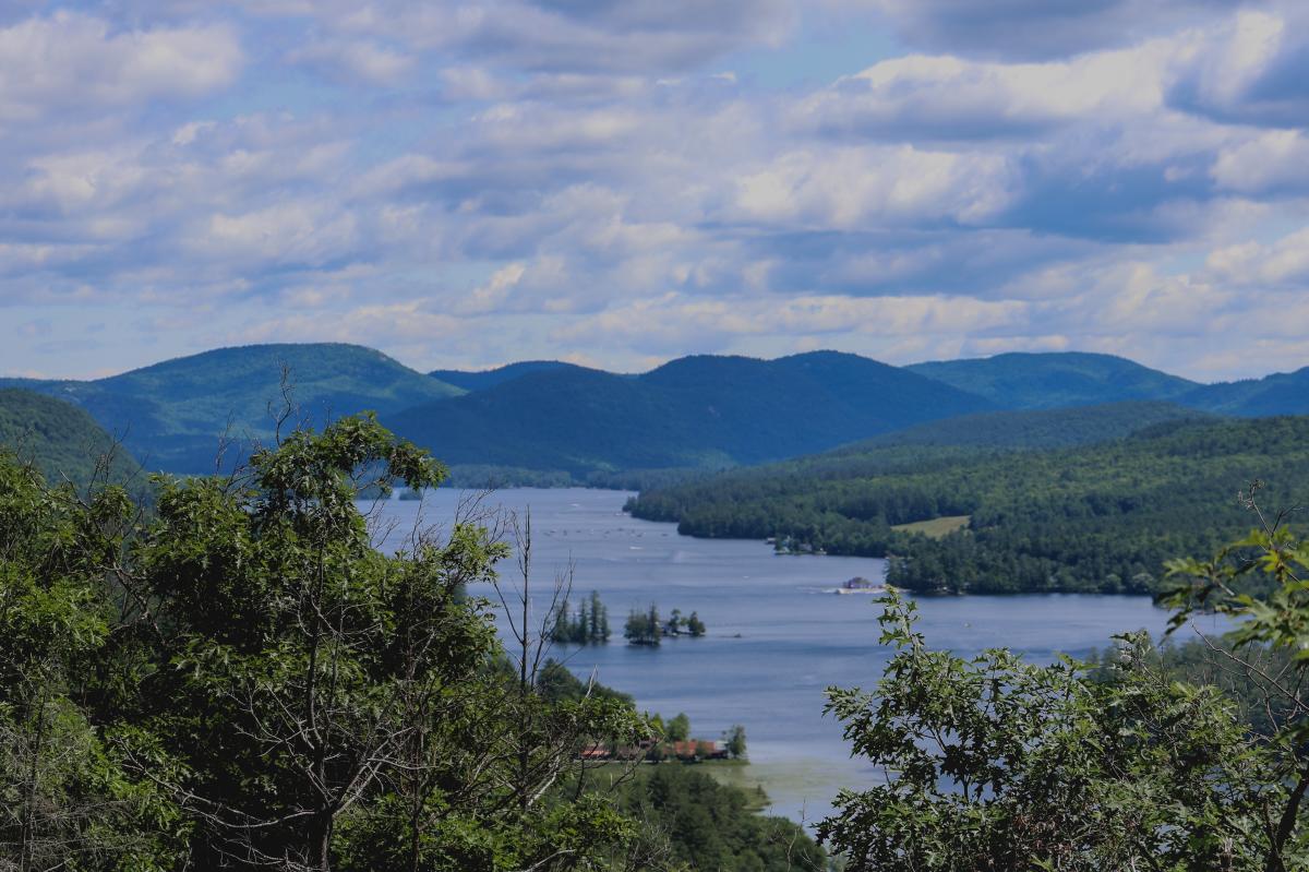
Pictured: A Sighting of Brant Lake from the Bartonville Mountain Trail; Photo Credit: Jaynie Ellis
*For more information, check out our Bartonville Mountain Hiking Trail listing.
Fox Hill Trail
Distance: 1.6 miles roundtrip, out-and-back
Difficulty: Easy - Moderate
Location/Parking: Town of Horicon Community Center – 6604 NY-8, Brant Lake
Trail Map: Fox Hill Trail Map
Located almost directly across Mill Pond from the Bartonville Mountain Trail, the Fox Hill Trail begins behind the Town of Horicon Community Center, where parking and the trailhead can be found at the back of the building.
After a short walk on a paved road leading uphill to the playground and little league field, you’ll begin to see trailhead signage behind the farthest dugout. Make sure to follow the yellow and black arrow markers to stay on the designated path throughout the woods.
Along the way, you’ll discover three unique overlooks. The first lookout provides a view of Mill Pond, and also includes a bench for hikers to take a short rest. The second one offers terrific sights of Gore Mountain. The third and final one at the summit offers gorgeous glimpses of Moxham Mountain, located further north in the Adirondacks.
Though this hike is shorter in length, the elevation is 1505 feet, and can be steep in certain spots. This trek does contain some scrambling. Because of loose rocks, the way back down tends to be trickier than going up. Sections of the hike are also along ridgelines, including the third overlook. Because of this, caution is advised when hiking in either direction.
During the months of July and August, you can also find Food Truck Fridays taking place in the Town of Horicon Community Center parking lot through the evening hours. This makes for a great spot to grab a bite before or after the hike, along with enjoying the local, live music scene.
Note: Due to steep, rocky sections, this hike may be considered “moderate,” even for more experienced hikers.
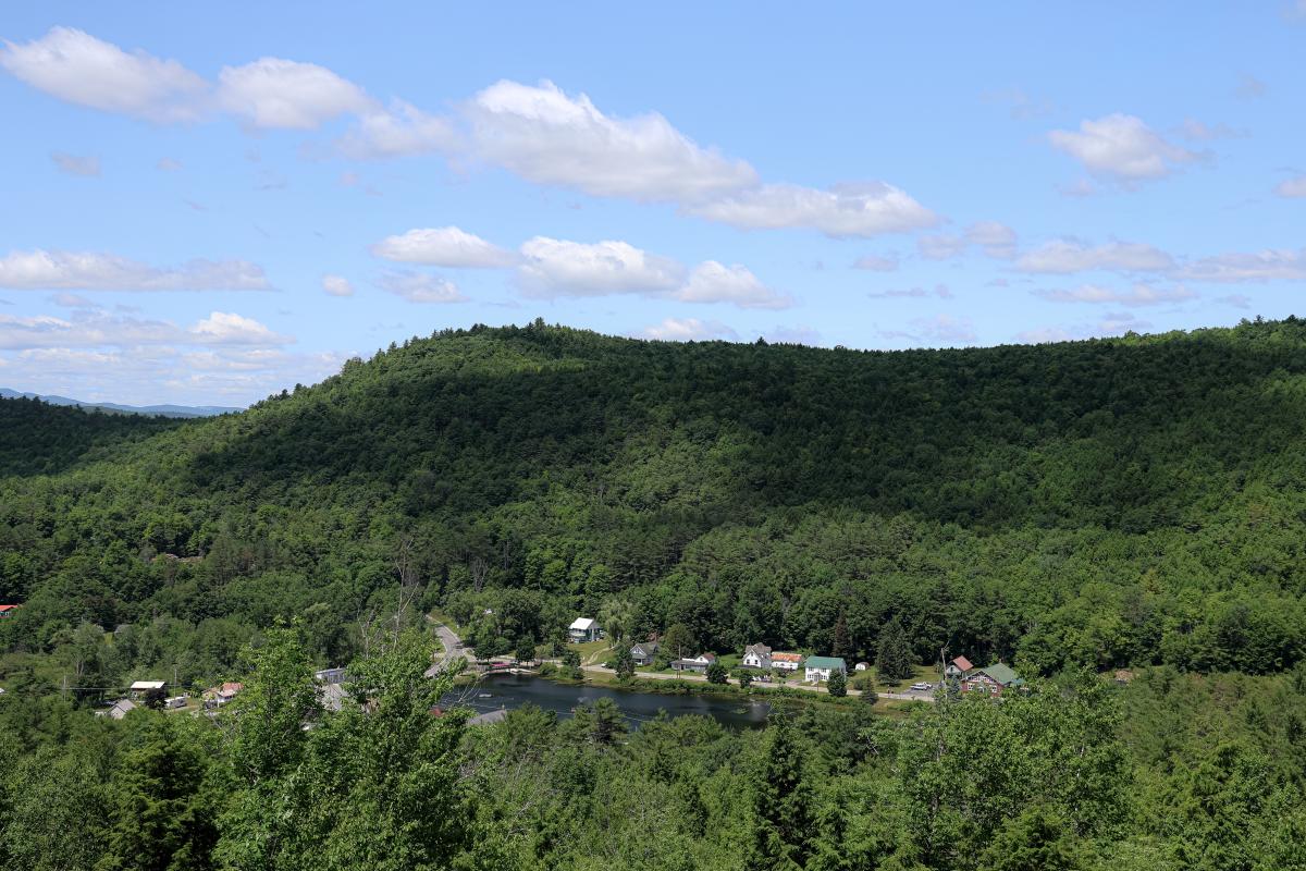
Pictured: A View from the Mill Pond Lookout on the Fox Hill Trail; Photo Credit: Jaynie Ellis
*For more information, check out our Fox Hill Trail listing.
Pharaoh Mountain Trail
Distance: 12.5 miles roundtrip, out-and-back
Difficulty: Difficult
Location/Parking: South Pharaoh Lake Parking (Pharaoh Road) - Adirondack
Trail Map: Pharaoh Mountain Trail Map
Pharaoh Mountain is certainly the toughest trek on the Brant Lake Challenge, with an estimated time of 6 to 7 hours to complete this 12.5-mile roundtrip.
To get to the trailhead parking area, in the small hamlet of Adirondack, you’ll want to take Exit 25 off the Northway (I-87) and a right from the off-ramp onto Route 8. From there, take a quick right onto Schroon River Road, which eventually turns into Valentine Pond Road. Look out for the right turn onto Johnson Road, then a right turn onto Beaver Pond Road, and finally a left on Pharaoh Road at the brown trailhead sign. There is a second parking lot further down an old dirt logging road, but this is passable for high-sitting vehicles only. As such, it is recommended to simply park at the first lot at the trailhead and take the 25-minute walk along the logging road to get further in.
If you’re having difficulty finding the trailhead, The Crossroads is a great point of reference to place in your phone or GPS. Located in Chestertown, near the intersection of Dixon and Schroon River Roads, this family-run shop is stocked with plenty of outdoor equipment—bug spray, gloves, ponchos, maps, etc.—if you need to grab any supplies before you hit the trail. Meanwhile, their deli and café offer various sandwiches and baked goods perfect for during or after the hike.
Much of the wilderness along the trail consists of wetlands, so if you end up hiking during or after a rainstorm, make sure you’re prepared for wet and muddy conditions. There have been reports of boardwalks and bridges out along the trail; be prepared in the event you have to wade across sections of water—thankfully no higher than knee-deep.
There are lean-tos and campsites along the trail, should you want to take a rest, or perhaps pitch a tent for the night and turn this into a two-day trek. While most of this trail is flat, the last two miles provide a steady ascent to the summit, with an elevation of 2556 feet. As such, the final portion of the climb is a more difficult hike; once you reach the summit, however, you’ll be rewarded with panoramic views of the Adirondack peaks, as well as the surrounding wilderness.
With such a lengthy distance, an important piece of advice is to pace yourself and know your limits. While the terrain itself isn’t too exhausting, less experienced hikers may become easily fatigued by distance alone. Make sure you take advantage of any available stopping points when needed.

Pictured: Part of the Wetlands on the Pharaoh Mountain Trail (as well as a Froggy Friend); Photo Credit: Jaynie Ellis
*For more information, check out our Pharaoh Mountain Trail listing.
Swede Mountain Trail
Distance: 1.8 miles roundtrip, out-and-back
Difficulty: Easy - Moderate
Location/Parking: Turnout along Route 8/Graphite Mountain Road
Trail Map: Swede Mountain Trail Map
Trailhead parking for the Swede Mountain Trail begins with a large pull-off alongside Route 8. To get to the trailhead itself, please note that you will need to hop the guardrail.
While there is a steep section of rock and wooden steps at the very beginning of the trail, the rest smooths out to provide an easy and family-friendly hike.
A majority of the trail tends to be a single-file path due to overgrown vegetation. As long as it’s not too hot, it’s not a bad idea to wear long pants, especially if you’re worried about insects or other animals lurking in the brush. The trail is marked with blue “STAY ON TRAIL” signs and blue arrow markers, so make sure you follow them at all times.
The path ahead eventually leads to the Swede Mountain Fire Tower, originally built in 1918 but taken out of service in 1968. Fortunately, the tower was refurbished in 2021 by Warren County, making it accessible for climbers. If you’re interested in learning more about the history of this fire tower, educational signage is generously placed at the trail summit.
Once you climb the fire tower, you will be rewarded with some fantastic 270-degree views—especially on clear weather days—of other Adirondack high peaks, including Gore, Crane, and 11th Mountains. There are also views of Giant Mountain—the 12th tallest Adirondack High Peak—and Blue Mountain—a very popular climbing mountain in the Adirondacks. You can even enjoy a glimpse of Brant Lake.
An important thing to note about the fire tower, however, is that only about 3 people can safely fit in the lookout at a time. Because of this, the recommended etiquette is to wait for the group already in the tower to climb down before heading up. That said, while the views are certainly worth taking a break for, please be considerate of others waiting and be mindful of the amount of time you spend in the lookout.
Note: Both the trail and the tower are closed from September through December for hunting season. Actual dates may vary year-to-year.
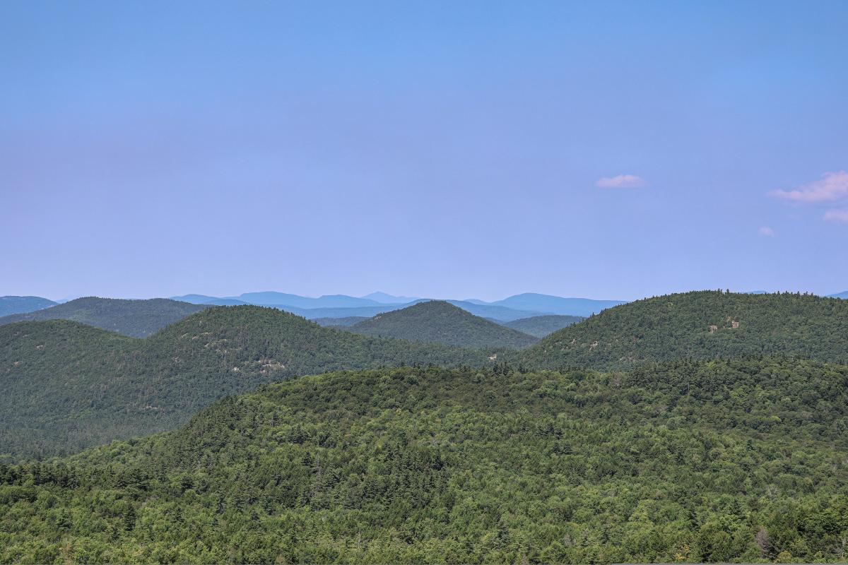
Pictured: A Scenic View from the Swede Fire Tower; Photo Credit: Jaynie Ellis
*For more information, check out our Swede Mountain Trail listing.